As the coldest, driest, windiest and fastest changing environment on Earth, Antarctica is a fascinating continent that still hides its secrets. For the last 60 years, scientists have explored and strived to better understand the past, present and future of the Antarctic Ice Sheet but also its geological structure. This is of particular importance in the context of rapid climatic changes where the melting of Antarctic Ice Sheet has a direct impact on the global sea level rise. One way to quantify how the ice sheet will respond to these changes is to collect data by conducting surveys of the ice and bedrock underneath using geophysical techniques such as gravity, magnetics, and radar. Staff at the Environmental Data Service (EDS) have collaboratively worked with researchers to improve accessibility to these important datasets by developing a new data portal.
Between 1994 and 2020, the British Antarctic Survey (BAS) flew 24 surveys over Antarctica with a total cumulative coverage of 5.3 million km² (equivalent to 1/3 of Antarctica or 20 times the size of the UK!). Data was acquired as part of large international collaborations1. These datasets were not easily accessible to the wider geophysical and glaciology communities, restricting the ability to extract further valuable information from them. Extensive work has been undertaken since 2020, by UK Polar Data Centre (part of the EDS) staff in partnership with the British Antarctic Survey airborne geophysics and mapping (MAGIC) teams to improve the FAIRness (findability, accessibility, interoperability and re-usability) of the datasets.
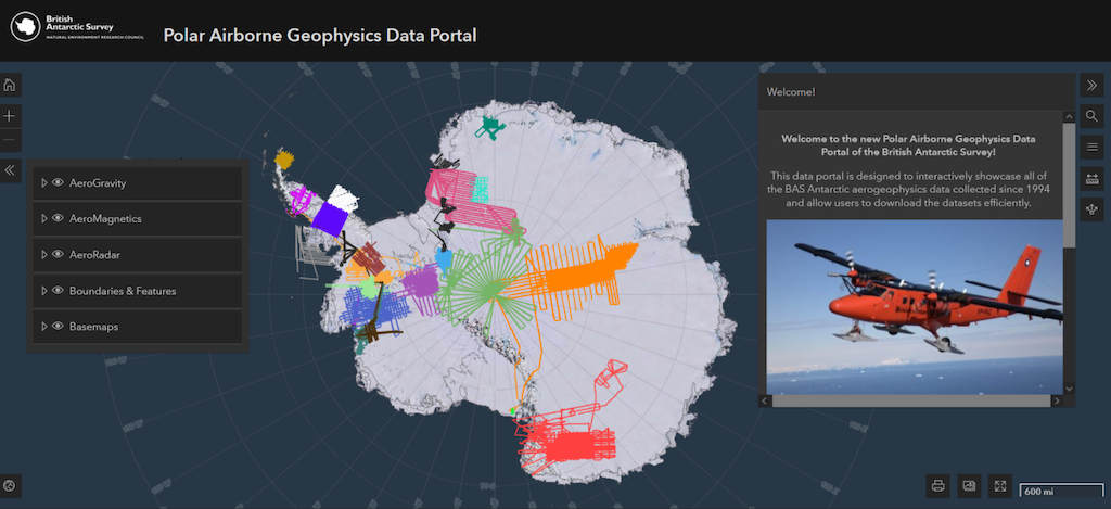
The Polar Airborne Geophysics Data Portal has been developed to provide a user-friendly and map-based interface–giving a first insight into the Antarctic ice sheet. The portal allows the users to discover the great resource that we hold, plan other surveys, or undertake further research.
Tom Jordan, leader of the airborne geophysics team says:
The Polar Airborne Geophysics data portal is a great resource for the Antarctic research community. By placing all the available BAS aerogeophysical data in one place it speeds up access, while the graphical interface means all relevant datasets are easily discovered. This accessibility, coupled with the ability to take a quick-look at the data, means researchers can rapidly find the data they need. As a contributor, the team at the UK Polar Data Centre made data upload straightforward, while ensuring all the meta-data was correct, meaning these datasets will have a long life forming the basis of Antarctic research.
Any user can quickly and easily look at the radargrams (or echography of the Earth) showing the different layering of the ice and bedrock in Antarctica. In total, 64 datasets (566 GB or ~1800 files) including magnetics, gravity, radar and bed elevation/ice thickness datasets have been published. An associated Geophysics Book offers a user’s guide, gives the list of data available and provides interactive codes to help scientists use the data with Python (or Matlab).
The portal is freely available to access here.
This project mixing data managers, researchers, and GIS specialists has led to increased interest in the airborne geophysics research and new collaborations showcasing the specialist skills and resources of the UK Polar Data Centre.
1These include the International Polar year AGAP, European Space Agency POLARGAP, and more recently the International Thwaites Glacier Collaboration projects. These data motivated the creation of large international science working groups, such as the Scientific Committee on Antarctic Research (SCAR) BEDMAP I/II/III, ADMAP (I/II) and AntArchitecture.