Ever wondered what Antarctica looks like underneath all that ice?
Antarctica is locked under 27 million km³ of ice, a layer that averages 2.1 km thick and is 4.8 km thick at its deepest. As the climate warms and the ice melts, the meltwater flows into the ocean, driving global sea level rise.
To provide policy makers with precise predictions on the scale and timing of this rise, climate modellers require high-resolution data on both the Antarctic ice sheet itself, and the landscape beneath the ice, which dictates the speed and direction of ice flow. For example, sub-glacial mountains can hold back the ice, whereas below-sea-level basins, if breached by seawater, will accelerate melting from beneath.
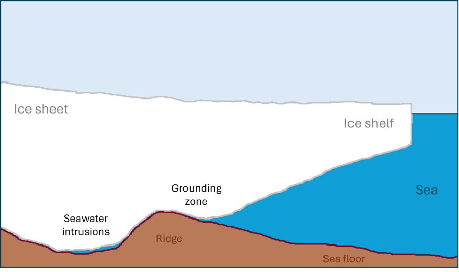
Figure 1. A diagram illustrating how below-sea-level sub-glacial basins, if breached by seawater, can accelerate the melting of an ice sheet from below.
For decades, the polar scientific community has been using a combination of aircraft-mounted, satellite-mounted, and even dog-sledge mounted radar, as well as seismic reflection and gravity sensors to measure the Antarctic ice sheet and underlying bedrock. When conducting such ambitious work in arguably the most inhospitable conditions on the planet, it makes sense to pool resources; after all, global sea-level rise affects everyone. So, in 2001, sponsored by the Scientific Committee on Antarctic Research (SCAR), a project began to compile existing Antarctic topographic data, called ‘Bedmap’. Standardising and integrating disparate international datasets is a real challenge, and this is where Natural Environment Research Council (NERC) Environmental Data Service (EDS) expertise can make a real difference.

Figure 2. Bed topography.
From Raw Data to Global Resource
Bedmap3, the most detailed topographic map of Antarctica to date, was only made possible by the data management expertise of the NERC EDS. Building on over 60 years of data collection, Bedmap3 was published in 2025, representing a massive leap in resolution from its predecessor. Incorporating 84 additional aerogeophysical surveys from 15 international data providers, 52 million data points have been added; double that of Bedmap2.
The NERC EDS was key to this international collaboration. Alice Frémand, Geophysical Data Manager at the UK Polar Data Centre (PDC), served as the third author on the project’s primary data paper. Her role was pivotal: Alice curated, aggregated, and standardised the vast influx of survey datasets, combining data from myriad sources into a cohesive, interoperable global product.

Figure 3. Surface elevation in metres above sea level and ice thickness in metres.
Impact
Bedmap is one of the most cited Antarctic research outputs, with approximately 130 annual citations prior to the release of Bedmap3. By hosting and managing these datasets, the NERC EDS ensures that this critical information remains "FAIR" (Findable, Accessible, Interoperable, and Reusable) for the global research community.
The Bedmap3 grids and the underlying survey data are now permanently archived and publicly available via the UK PDC, ensuring that the next generation of climate models are built on a foundation of the most robust data possible.
Through work like Bedmap3, the NERC EDS does more than just store data; it enables the international coordination necessary to understand the future of our planet.
References
Pritchard, H.D., Fretwell, P.T., Frémand, A.C. et al. Bedmap3 updated ice bed, surface and thickness gridded datasets for Antarctica. Sci Data 12, 414 (2025). https://doi.org/10.1038/s41597-025-04672-y
Frémand, A. C., Fretwell, P., Bodart, J. A., Pritchard, H. D., Aitken, A., Bamber, J. L., Bell, R., Bianchi, C., Bingham, R. G., Blankenship, D. D., Casassa, G., Catania, G., Christianson, K., Conway, H., Corr, H. F. J., Cui, X., Damaske, D., Damm, V., Drews, R., Eagles, G., Eisen, O., Eisermann, H., Ferraccioli, F., Field, E., Forsberg, R., Franke, S., Fujita, S., Gim, Y., Goel, V., Gogineni, S. P., Greenbaum, J., Hills, B., Hindmarsh, R. C. A., Hoffman, A. O., Holmlund, P., Holschuh, N., Holt, J. W., Horlings, A. N., Humbert, A., Jacobel, R. W., Jansen, D., Jenkins, A., Jokat, W., Jordan, T., King, E., Kohler, J., Krabill, W., Kusk Gillespie, M., Langley, K., Lee, J., Leitchenkov, G., Leuschen, C., Luyendyk, B., MacGregor, J., MacKie, E., Matsuoka, K., Morlighem, M., Mouginot, J., Nitsche, F. O., Nogi, Y., Nost, O. A., Paden, J., Pattyn, F., Popov, S. V., Rignot, E., Rippin, D. M., Rivera, A., Roberts, J., Ross, N., Ruppel, A., Schroeder, D. M., Siegert, M. J., Smith, A. M., Steinhage, D., Studinger, M., Sun, B., Tabacco, I., Tinto, K., Urbini, S., Vaughan, D., Welch, B. C., Wilson, D. S., Young, D. A., and Zirizzotti, A. (2023). Antarctic Bedmap data: Findable, Accessible, Interoperable, and Reusable (FAIR) sharing of 60 years of ice bed, surface, and thickness data, Earth Syst. Sci. Data, 15, 2695-2710, https://doi.org/10.5194/essd-15-2695-2023
Fretwell, P., Pritchard, H. D., Vaughan, D. G., Bamber, J. L., Barrand, N. E., Bell, R., Bianchi, C., Bingham, R. G., Blankenship, D. D., Casassa, G., Catania, G., Callens, D., Conway, H., Cook, A. J., Corr, H. F. J., Damaske, D., Damm, V., Ferraccioli, F., Forsberg, R., Fujita, S., Gim, Y., Gogineni, P., Griggs, J. A., Hindmarsh, R. C. A., Holmlund, P., Holt, J. W., Jacobel, R. W., Jenkins, A., Jokat, W., Jordan, T., King, E. C., Kohler, J., Krabill, W., Riger-Kusk, M., Langley, K. A., Leitchenkov, G., Leuschen, C., Luyendyk, B. P., Matsuoka, K., Mouginot, J., Nitsche, F. O., Nogi, Y., Nost, O. A., Popov, S. V., Rignot, E., Rippin, D. M., Rivera, A., Roberts, J., Ross, N., Siegert, M. J., Smith, A. M., Steinhage, D., Studinger, M., Sun, B., Tinto, B. K., Welch, B. C., Wilson, D., Young, D. A., Xiangbin, C., and Zirizzotti, A. (2013). Bedmap2: improved ice bed, surface and thickness datasets for Antarctica, The Cryosphere, 7, 375-393, https://doi.org/10.5194/tc-7-375-2013
Lythe, M. B. and Vaughan, D. G. (2000). BEDMAP-bed topography of the Antarctic, British Antarctic Survey, Natural Environment Research Council
Lythe, M. B. and Vaughan, D. G. (2001). BEDMAP: A new ice thickness and subglacial topographic model of Antarctica, Journal of Geophysical Research: Solid Earth, 106, 11335-11351, https://doi.org/10.1029/2000JB900449
Data
BEDMAP1
Lythe, M., Vaughan, D., BEDMAP 1, consortia, Frémand, A., & Bodart, J. (2022). BEDMAP1 - Ice thickness, bed and surface elevation for Antarctica - standardised data points (Version 1.0) [Data set]. NERC EDS UK Polar Data Centre. https://doi.org/10.5285/F64815EC-4077-4432-9F55-0CE230F46029
Lythe, M., Vaughan, D., BEDMAP 1, consortia, Frémand, A., & Bodart, J. (2022). BEDMAP1 - Ice thickness, bed and surface elevation for Antarctica - standardised shapefiles and geopackages (Version 1.0) [Data set]. NERC EDS UK Polar Data Centre. https://doi.org/10.5285/925AC4EC-2A9D-461A-BFAA-6314EB0888C8
BEDMAP2
Fretwell, P., Frémand, A., Bodart, J., Pritchard, H., Vaughan, D., Bamber, J., Barrand, N., Bell, R. E., Bianchi, C., Bingham, R., Blankenship, D., Casassa, G., Catania, G., Callens, D., Conway, H., Cook, A., Corr, H., Damaske, D., Damn, V., ... Zirizzotti, A. (2022). BEDMAP2 - Ice thickness, bed and surface elevation for Antarctica - standardised data points (Version 1.0) [Data set]. NERC EDS UK Polar Data Centre. https://doi.org/10.5285/2FD95199-365E-4DA1-AE26-3B6D48B3E6AC
Fretwell, P., Pritchard, H., Vaughan, D., Bamber, J., Barrand, N., Bell, R. E., Bianchi, C., Bingham, R., Blankenship, D., Casassa, G., Catania, G., Callens, D., Conway, H., Cook, A., Corr, H., Damaske, D., Damn, V., Ferraccioli, F., Forsberg, R., ... Bodart, J. (2022). BEDMAP2 - Ice thickness, bed and surface elevation for Antarctica - standardised shapefiles and geopackages (Version 1.0) [Data set]. NERC EDS UK Polar Data Centre. https://doi.org/10.5285/0F90D926-99CE-43C9-B536-0C7791D1728B
Fretwell, P., Pritchard, H., Vaughan, D., Bamber, J., Barrand, N., Bell, R. E., Bianchi, C., Bingham, R., Blankenship, D., Casassa, G., Catania, G., Callens, D., Conway, H., Cook, A., Corr, H., Damaske, D., Damn, V., Ferraccioli, F., Forsberg, R., ... Zirizzotti, A. (2022). BEDMAP2 - Ice thickness, bed and surface elevation for Antarctica - gridding products (Version 1.0) [Data set]. NERC EDS UK Polar Data Centre. https://doi.org/10.5285/FA5D606C-DC95-47EE-9016-7A82E446F2F2
BEDMAP3
Frémand, A., Fretwell, P., Bodart, J., Pritchard, H., Aitken, A., Bamber, J., Bell, R. E., Bianchi, C., Bingham, R., Blankenship, D., Casassa, G., Catania, G., Christianson, K., Conway, H., Corr, H., Cui, X., Damaske, D., Damn, V., Drews, R., .... Zirizzotti, A. (2022). BEDMAP3 - Ice thickness, bed and surface elevation for Antarctica - standardised data points (Version 1.0) [Data set]. NERC EDS UK Polar Data Centre. https://doi.org/10.5285/91523FF9-D621-46B3-87F7-FFB6EFCD1847
Fretwell, P., Pritchard, H., Frémand, A., Bodart, J., Aitken, A., Bamber, J., Bell, R. E., Bianchi, C., Bingham, R., Blankenship, D., Casassa, G., Catania, G., Christianson, K., Conway, H., Corr, H., Cui, X., Damaske, D., Damn, V., Drews, R., ... Zirizzotti, A. (2022). BEDMAP3 - Ice thickness, bed and surface elevation for Antarctica - standardised shapefiles and geopackages (Version 1.0) [Data set]. NERC EDS UK Polar Data Centre. https://doi.org/10.5285/A72A50C6-A829-4E12-9F9A-5A683A1ACC4A
Pritchard, H., Fretwell, P., Frémand, A., Bodart, J., Kirkham, J., Aitken, A., Bamber, J., Bell, R., Bianchi, C., Bingham, R., Blankenship, D., Casassa, G., Catania, G., Christianson, K., Conway, H., Corr, H., Cui, X., Damaske, D., Damn, V., ... Zirizzotti, A. (2024). BEDMAP3 - Ice thickness, bed and surface elevation for Antarctica - gridding products (Version 1.0) [Data set]. NERC EDS UK Polar Data Centre. https://doi.org/10.5285/2d0e4791-8e20-46a3-80e4-f5f6716025d2