Space Weather
On Friday May 10th, the UK was treated to a display of the northern lights (aurora borealis) the likes of which had not been seen for at least 20 years. Whilst many of us in the UK and around the world got to tick this awe-inspiring sight off our bucket lists, those who operate satellites, work in aviation, or manage power grids were on high alert. This is because the same charged particles and magnetic fields from the sun that, when interacting with the Earth’s magnetic field and atmosphere produce the aurora, can also negatively affect our critical infrastructure systems.
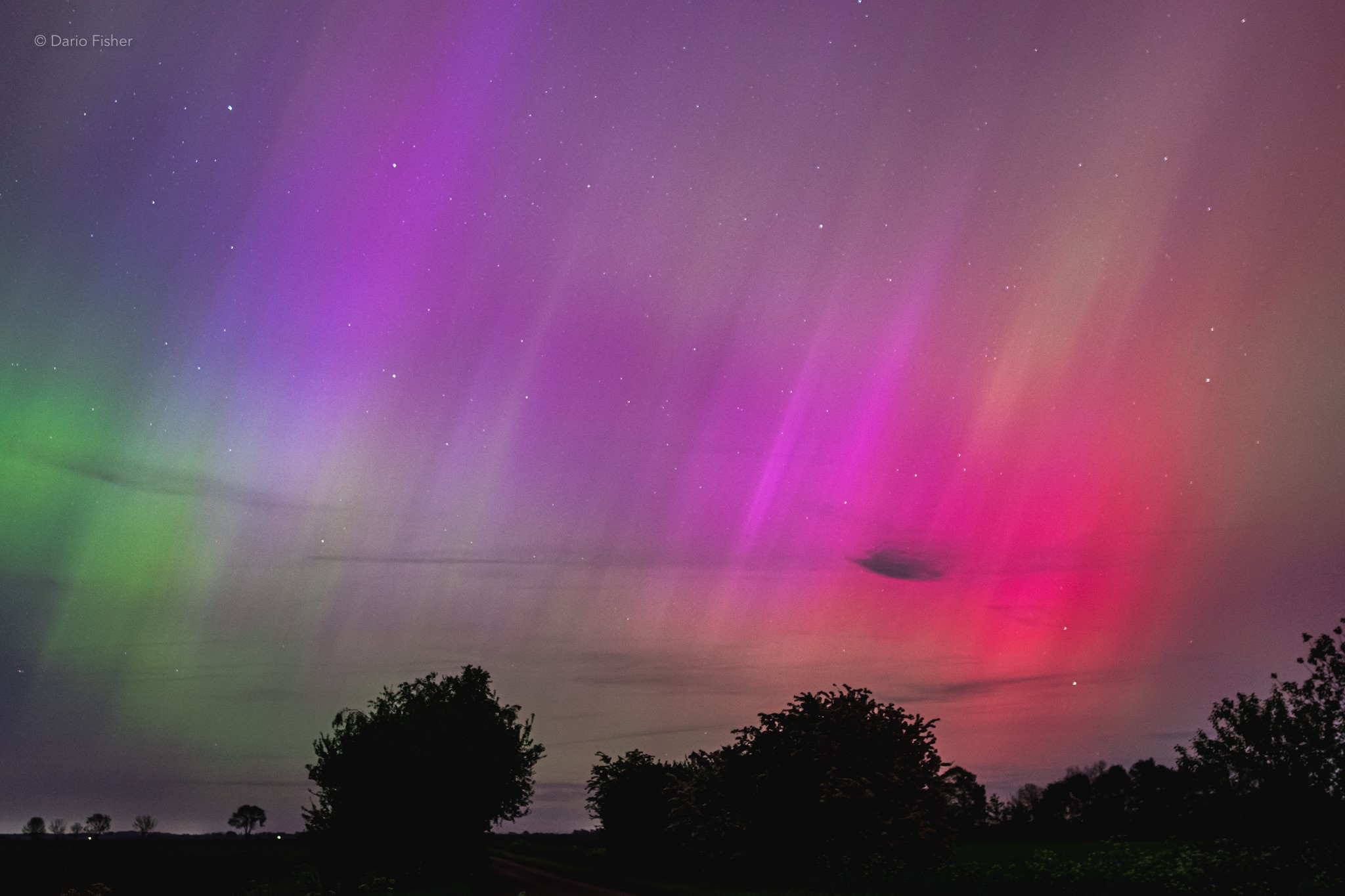
Figure 1. Photograph of the aurora taken from the Cambridgeshire countryside Friday 10th May 2024. Credit: © Dario Fisher.
Hazards
The main impacts of extreme space weather are:
-
Satellite drag. Increased solar radiation heats the upper atmosphere, causing it to expand and rise into the zone where most satellites are located. This increases the density there, increasing the drag experienced by the satellites, slowing them down. This causes them to lose altitude (orbital decay). This necessitates the burning of on-board fuel reserves to boost them up to their original orbit. As a finite resource, using fuel decreases the total lifetime of the satellite.
-
Satellite damage. During large geomagnetic storms, satellites in orbit around the Earth are exposed to more high-energy charged particles than usual. This can cause a buildup of charge within the electronic circuitry onboard, which, on discharge, can damage the electronics. The same process can also occur in aircraft electronics.
-
Increased radiation dosage at high altitude. The same high-energy charged particles that can damage satellites can also damage living cells. Astronauts and airline passengers are exposed to higher levels of radiation than at ground-level, but this dosage increases by orders of magnitude during large solar storms.
-
Radio wave disturbance. Space weather changes the density of the ionosphere, which distorts radio signals travelling through it. This affects communications between Global Positioning Satellites (GPS) satellites and the ground, making navigation less accurate, or even causing a complete loss of signal. High Frequency (HF) radio, used by the aviation and marine industries amongst others, can also be disrupted.
-
Electricity grid disruptions. Interactions between the solar wind and the Earth’s magnetic field can induce uncontrolled electric currents in power grids on the Earth’s surface. This damages or even destroys transformers, which could cause blackouts.
The Risk
Because of these negative effects, space weather is on the UK’s National Risk Register of Civil Emergencies, with the impact level given as ‘significant’. As we increasingly rely on space-based technologies such as communications, global positioning, and timekeeping systems, a severe solar storm could cause billions of pounds worth of damage. We can’t stop these natural events from happening, but we can model them to help prepare, and produce forecasts that give time to take mitigating actions.
Protecting Critical Infrastructure
In a series of European Union (EU) projects and projects supported by the NERC, members of the Space Weather team at BAS have developed a system that runs satellite data through the BAS Radiation Belt Model (BAS-RBM) to produce space weather forecasts. The UK Met Office uses this system in its national space weather forecasting service, mitigating the impact that extreme space weather events could have on the UK.
Role of the EDS
One of the key areas of expertise within the EDS is the ability to create data pipelines controlling the flow of data from source, into models, out of models, and into data products. NERC EDS data manager Peter Kirsch, who works at the UK Polar Data Centre (PDC), demonstrated these skills when developing SaRIF (Satellite Risk Prediction and Radiation Forecasts), one of the projects mentioned above. His work inputs satellite data to the BAS-RBM and outputs the information to an online dashboard. More details are available in the article published on the EDS website back in 2021.
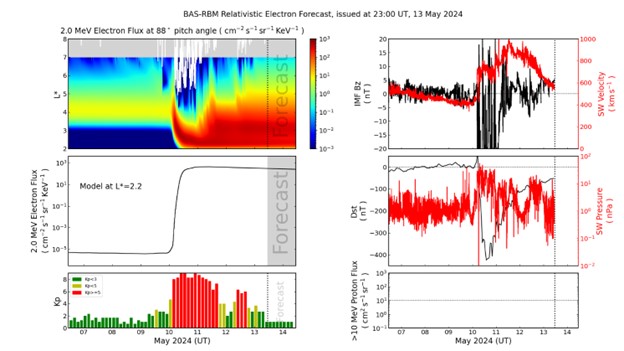
Figure 2. Screenshot from the SaRIF dashboard, dated 13th May 2024, depicting the 10th May space weather event.
Recognition
A 4-person BAS Space Weather team, including Peter, had their vital work recognised in the 2023 NERC Impact Awards. These awards aim to celebrate “Researchers whose work has had a significant, wide-reaching impact on the economy, society or environment”. The team won the Economic Impact Award with their entry Reducing risks to satellites through daily space weather forecasts. It’s superb to hear that the hard work and expertise of a member of the NERC EDS has been recognised at a national level.