
The UK’s journey to net zero relies on a huge network of offshore infrastructure. Subsea power cables connect offshore wind farms to the national grid, while telecommunication cables carry more than 95% of international digital data. Yet these assets face risks from ship anchors, fishing activity, dredging and natural hazards. To protect them, engineers need to know how deep cables should be buried.
New research by The British Geological Survey (BGS), in collaboration with Durham University and University of Dundee, have shown how well-managed geoscience data can improve decisions about offshore infrastructure. The National Geoscience Data Centre (NGDC), part of the Environmental Data Service, provided geoscience data to support this work.
Turning decades of records into useful insights
To determine safe cable burial depths, engineers need a detailed understanding of the shallow sediments beneath it. The current Cable Burial Risk Assessment (CBRA) practice relies on simplified assumptions, modelling the seabed as a uniform layer of sand or clay. In reality, the seabed is much more varied. Differences in sediment layers, density and strength can affect cable burial and anchor penetration. Assessing this variability depends on access to geological and geotechnical datasets capable of characterising subsurface conditions at a regional scale.
The project combined over 12,000 geological records from BGS (NGDC) and The Crown Estate’s Marine Data Exchange (MDE). This created a detailed picture of shallow subsurface conditions across the UK North Sea. These records included decades of legacy data preserved within the BGS Offshore GeoIndex alongside more recent industry investigation data available through The Crown Estate’s MDE.
The data originated from a wide variety of acquisition techniques and investigation purposes, resulting in different logging conventions and file formats. Many of NGDC’s records originated from scanned handwritten logs, some dating back to the 1950s whereas, MDE’s data are more recent (post-2000) from numerous offshore site investigations undertaken by different contractors. Given the differences in file formats (PDF, Excel, AGS, shapefiles), all records were digitised and transformed into a standardised format to ensure consistent analysis.
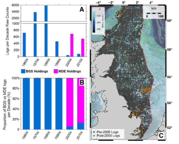
Figure 1 (A) Number of geotechnical investigation logs per decade, separated into BGS legacy holdings and Marine Data Exchange (MDE) data holdings (© The Crown Estate, 2025; © Crown Estate Scotland 2022). (B) Proportion of BGS and MDE log holdings by decade. (C) Spatial distribution of pre-2000 and post-2000 site investigation locations. Legacy (pre-2000) sites are broadly distributed across the UK North Sea, whereas post-2000 sites form concentrated clusters in areas of recent offshore wind development. Coastline after Wessel & Smith (1996). BGS © UKRI 2026.
The dataset comprised of:
- 10,607 shallow cores (such as gravity cores and vibrocores) sampling the upper 0 to 6m below seabed (mbsb)
- 1,024 boreholes and Cone Penetration Tests (CPTs) extending to greater depths
- a smaller number of box cores, trial pits and piston cores
This work highlights the long-term value of data stewardship. Information collected decades ago for different purposes can help solve new challenges when properly curated, preserved and made accessible.
Revealing the hidden complexity of the North Sea seabed
The findings challenge the common assumption that the seabed can be represented by a single uniform soil type. Analysis showed that 77% of geological logs extending at least 2m below seabed contained two or more lithological layers, showing that layered and varied ground conditions are the norm rather than the exception.
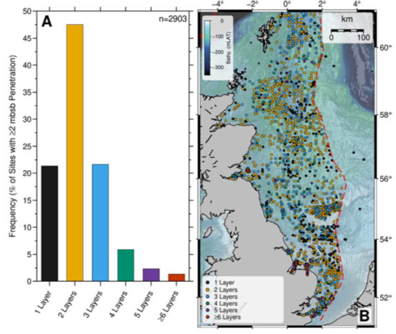
Figure 2 (A) Frequency of geotechnical layers within the upper 2 mbsb, based on all sites with ≥2 mbsb penetration depth (n=2903 sites). Most investigations contain one to three distinct layers. (B) Spatial distribution of layer counts: higher layer counts highlight areas with more variable shallow stratigraphy, whereas single-layer sites are associated with more uniform surficial sediments. Only sites with ≥2 mbsb penetration depth are shown. Contains © British Geological Survey, 2024; © The Crown Estate, 2025; © Crown Estate Scotland 2022 data. Coastline after Wessel & Smith (1996). BGS © UKRI 2026.
The study also showed that coarse sediments are widespread across the UK North Sea. Thin gravel layers occur frequently, while thicker gravel deposits and shallow bedrock are more concentrated in nearshore areas, where they can present significant challenges to cable burial.
Organic rich sediments and peats are less common. They occur mainly in the southern North Sea and are often hidden beneath thin sand layers, making them difficult to identify through seabed mapping alone.
By providing evidence of this complexity, the dataset is helping engineers, planners and researchers move beyond simplified representations of the seabed towards more realistic assessments of the subsurface conditions.
Data is infrastructure
A key lesson from the project is that data itself is infrastructure.
The success of the study depended not only on the availability of NGDC’s geological records but also on the ability to combine and standardise data from multiple sources. The resulting database provides a framework that others can use for future research, engineering studies and regional assessments across the UK Continental Shelf.
The project shows how sustained investment in data management, digitisation and long-term stewardship can unlock new value from existing datasets. By preserving geological information and improving access to it, NGDC helps make sure knowledge collected over many decades continues to inform future infrastructure decisions.
Reference
Macdonald, C.; Stevens, D.. 2026 Characterising shallow subsurface variability in the UK North Sea: a regional analysis using geotechnical records. Nottingham, UK, British Geological Survey, 39pp. (OR/26/019) (Unpublished)