It is hoped that emerging Artificial Intelligence (AI) technologies will scale up biodiversity monitoring by automating species identification from imagery. A major barrier to scaling up the use of AI for biodiversity monitoring is the lack of workflows and tools to support AI to deliver robust and meaningful biodiversity metrics.
In a step towards tackling this, a new way of submitting imagery metadata using the image FAIR Data Object (iFDO) standard has been developed at the British Oceanographic Data Centre (BODC). This is part of the ‘Pipelines for Supporting AI for Biodiversity Monitoring from Imagery’ (PAIDIVER) project, funded as part of Natural Environment Research Council’s (NERC) ‘Tools for Automated Image Analysis for Biodiversity Monitoring (AIAB)’ programme.
BODC is the oceanographic data archive centre within the NERC Environmental Data Service (EDS). The new image data submission form has been created within BODC’s established data submissions portal. This supports users in submitting imagery metadata that conforms to the iFDO metadata standard, with a view to making associated image datasets FAIR. Users manually fill in an iFDO metadata template, available from the BODC website , and load it via the portal, where the majority of fields are auto-populated. The submission of the associated images are arranged directly with BODC colleagues. As a result, image datasets that have been submitted using the new workflow are now externally visible on the PAIDIVER project Github space.
Further work is planned in 2026, to integrate image annotations that are output from popular annotation platforms (e.g. BIIGLE) into BODC’s database. BODC also plan to develop a demonstrator image brokerage service, building on the work undertaken earlier this year by the Join Nature Conservation Committee (JNCC). As a proof-of-concept tool, it will provide functionality to make annotations findable, searchable, and filterable across more than one image repository (BODC and JNCC), and return the images associated with those annotations.
This work will enable a standardised route for UK imagery submissions that conforms to FAIR principles, and through the brokerage service this will facilitate the availability of datasets for AI annotation model training, all with the ultimate aim of improving biodiversity monitoring efforts.
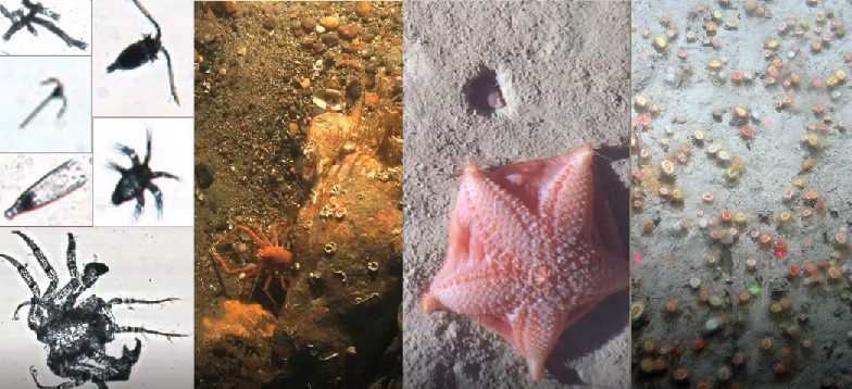
Figure references
First panel: From - Pitois S.G., Blackwell R.E., Close H., Eftekhari N., Giering S.L.C., Masoudi M., Payne E., Ribeiro J., Scott J., 2025. RAPID: real-time automated plankton identification dashboard using Edge AI at sea. Front. Mar. Sci., 11. https://doi.org/10.3389/fmars.2024.1513463
Second and fourth panel: From the Haig Fras Marine Protected Area https://jncc.gov.uk/our-work/haig-fras-mpa/
Third panel: From the Porcupine Abyssal Plain - Vieira, R.P., Bett, B.J., Jones, D.O.B., Durden, J.M., Morris, K.J., Cunha, M.R., Trueman, C.N., Ruhl, H.A., 2020. Deep-sea sponge aggregations (Pheronema carpenteri) in the Porcupine Seabight (NE Atlantic) potentially degraded by demersal fishing. Progr. Oceanogr., 183. https://doi.org/10.1016/j.pocean.2019.102189